
Laboratory of Modeling Hydrogeological Processes
Laboratory Head: Prof. Jacek Gurwin
e-mail: jacek.gurwin/at/uwr.edu.pl
Laboratory of Modeling Hydrogeological Processes
Department of Applied Hydrogeology, Institute of Geological Sciences of the University of Wrocław
ul. Cybulskiego 34, 50-205 Wrocław
tel. 71 375 92 42
Description of activities
The activities of the Laboratory of Modeling Hydrogeological Processes are focused on hydrogeological work and the protection of the aquatic environment. It aims to implement modern geoinformatics techniques in water resources management, primarily numerical filtration models, which form the basis in hydrogeology for calculations of circulation systems, replenishment, water balance, and groundwater resources. Calibration and verification of the model on a regional or local scale, as well as predictive simulations, must be based on field observations and hydrogeological monitoring data. Thus, the priority is the construction of automatic monitoring systems, including ADAS (Automatic Data Acquisition Systems) measurement stations. Modeling includes the quantitative and qualitative characterization of renewability and groundwater resources in a designated aquifer system (drainage basin, groundwater bodies, balance area).
Addressed issues include:
- Designing and optimizing the way groundwater intakes are exploited;
- Decision support regarding groundwater use and sustainable water resource management in the basin, assessment of disposable resources;
- Designation of protection zones for groundwater intakes and protected areas of Major Groundwater Reservoirs;
- Forecasts of changes in the aquatic environment under anthropogenic pressure, including: modeling pollution migration from landfills and other sources, the impact of mining activities on groundwater resources.
- Interdisciplinary geoecological studies of dam reservoirs and lakes, including modeling of surface water-groundwater interactions;
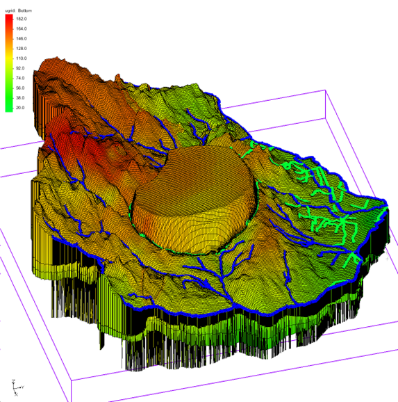
Integration of modeling work in a GIS environment ensures proper processing of input data, including using geostatistical modeling and excellent visualization of the final research results. Using multispectral satellite images (Remote Sensing) effectively aids in the spatial interpretation of environmental elements, complementing the designed terrestrial monitoring system. Integration of the described advanced geoinformatics techniques has already been successfully employed on many research sites.
Equipment of the Laboratory
Software used in numerical modeling of groundwater filtration and pollution migration.
It includes the latest and most advanced software packages, based on the global standard MODFLOW/MODPATH/MT3DMS and other programs for solving specific hydrogeological issues:
– Groundwater Modeling System GMS v. 10.7
– Groundwater VISTAS v. 5.0
– Visual Modflow VM v. 9.1
– Processing Modflow PM v. 8.0
– USG-Transport
– HYDRUS 2-D
– FLOWPATH II
– FEMWATER
– Aquifer Test Pro v. 9.0
– HYDROGEOCHEM
– CXTFIT
– ASMWin
– MicroFEM
Integration of models with GIS / RS systems:
– ArcGIS v. 10.7
– ILWIS v. 4.2
– GeoMedia Professional
– Mapinfo v. 7.5
– SURFER v. 17.1
– GRAPHER 15.0
– MicroStation V8i
and others.

